Long-distance drives across the United States reveal a scale that short visits rarely capture. A route can begin in red-rock desert, climb toward alpine lakes, pass through forested valleys, and finish under a sky that looks completely different from where the day started.
The best drives are not only about covering miles. They give travelers enough time to watch the landscape change through the windshield, stop when something looks interesting, and build a trip around the road instead of treating it as dead time between attractions.
Planning still matters. National parks can have seasonal road closures, shuttle systems, tour reservations, limited fuel stops, and crowded trailheads. A route that looks simple on a map can feel much longer once mountain roads, desert heat, wildlife traffic, and parking delays enter the day.
These five road trips reward travelers who leave room in the schedule. Each one links major scenery with enough variety to keep the drive interesting, from Utah’s sandstone parks to Wyoming’s geysers, California’s granite walls, and the desert landscapes of the Four Corners.
1. Utah’s Red Rock Loop: Arches, Canyonlands, and Capitol Reef
Southeastern Utah makes one of the clearest cases for building a trip around the drive. Around Moab, Arches National Park brings the quick-hit drama: sandstone fins, short walks to famous natural arches, and glowing desert scenery close to town.
The park will not require advanced timed-entry reservations in 2026, according to the National Park Service, although entrance fees still apply and reservations are still needed for Devils Garden Campground and Fiery Furnace access. Crowds can still trigger traffic delays or temporary entrance management on busy days, so early starts remain useful.
Nearby Canyonlands National Park changes the scale of the trip. Island in the Sky is the easiest district to fit into a Moab-based route, with overlooks above deep canyons carved by the Colorado and Green rivers. The park’s districts are not connected by internal roads, so travelers should not treat “doing Canyonlands” as one quick loop unless they are focusing on one area.
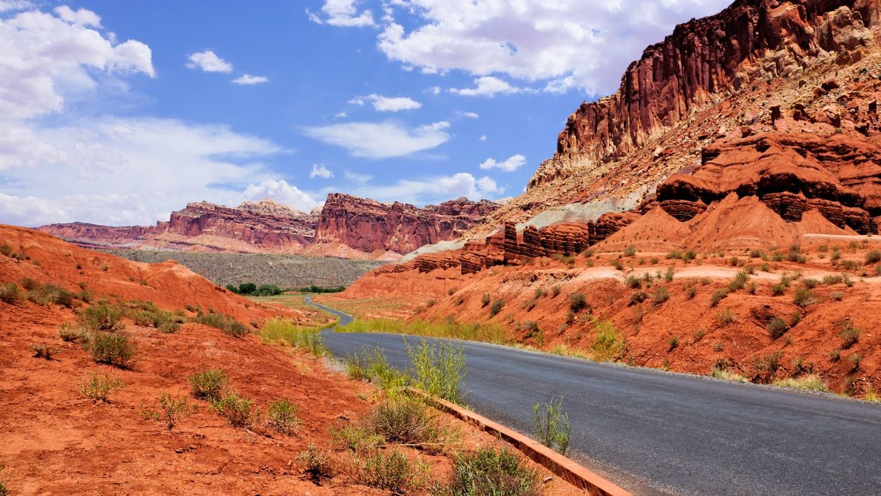
Farther west, Capitol Reef slows the pace with cliffs, orchards, old settlement history, and a paved Scenic Drive that reaches into canyon country near the visitor center. Weather can close the Scenic Drive and its dirt spur roads after snow, mud, ice, or flash flooding, so road conditions deserve a quick check before committing to the day.
This route feels best in spring or fall, when the heat is less punishing and the light still gives the rock its full color. Fuel and services thin out between towns, especially once the route leaves the Moab area, so topping up before long stretches keeps the trip relaxed.
2. Wyoming to Montana: Yellowstone and Grand Teton Corridor
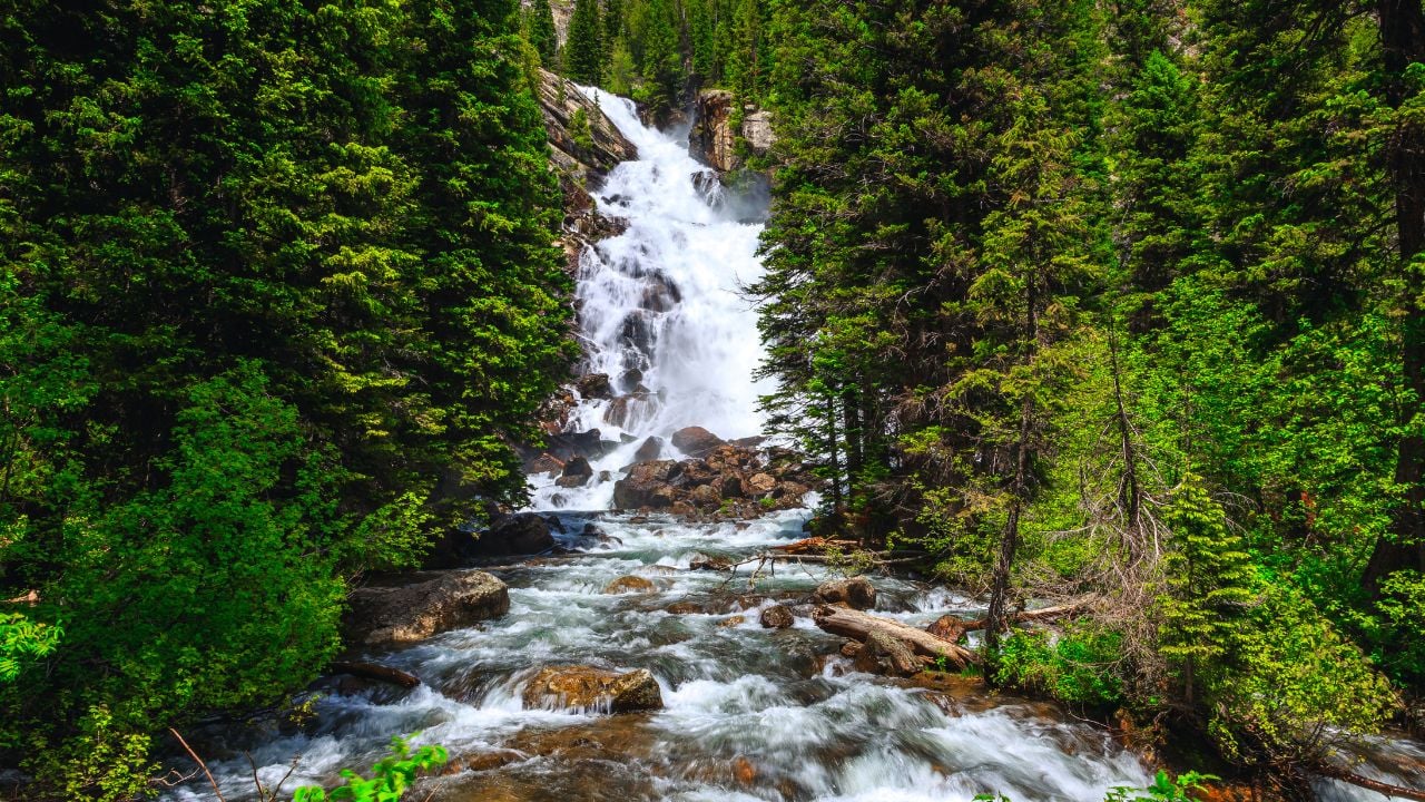
The drive between Grand Teton and Yellowstone delivers one of the great landscape shifts in the American West. Grand Teton National Park opens with sharp peaks, glacial lakes, and meadows where wildlife often appears close to the road.
The John D. Rockefeller, Jr. Memorial Parkway connects Grand Teton and Yellowstone, turning the transfer between parks into part of the experience rather than a blank driving day. Early morning is especially strong around Jackson Lake and the Teton viewpoints, when calm water and low light can make the mountains feel even larger.
Seasonal details can shape the Grand Teton portion of the trip. Jenny Lake is one of the park’s most popular areas, and the seasonal boat shuttle can shorten the route toward Hidden Falls and Inspiration Point when it is operating. Parking still fills quickly in peak season, so an early start can save more time than any later shortcut.
North of the parkway, Yellowstone shifts the drive into geysers, hot springs, bison meadows, waterfalls, and broad volcanic plateaus. Old Faithful remains the famous stop, but Lamar Valley and Hayden Valley give the trip a slower wildlife rhythm when the timing is right.
Yellowstone’s road system is seasonal and weather-sensitive. The park’s current conditions page notes that only the road between Mammoth Hot Springs and the Northeast Entrance is typically open to regular traffic year-round, weather permitting. Anyone planning this route outside the main summer window should check road status before locking in lodging.
3. California’s Sierra Route: Yosemite to Sequoia and Kings Canyon
California’s Sierra Nevada gives road-trippers granite cliffs, waterfalls, big trees, and mountain roads that demand patience. Yosemite National Park often anchors the northern end of the route, with Yosemite Valley putting El Capitan, Half Dome, meadows, and famous waterfalls into one concentrated landscape.
Yosemite will not require entrance reservations in 2026, according to the park’s reservation page, but that does not mean the park will feel empty. Parking and traffic can still become difficult during peak periods, especially in Yosemite Valley.
Spring brings the strongest waterfall season. The National Park Service says Yosemite waterfalls are generally best in spring, with peak runoff often happening in May or June and some falls dropping to a trickle or drying out by August. Late summer can still be beautiful, but the trip feels drier and more hiking-focused.
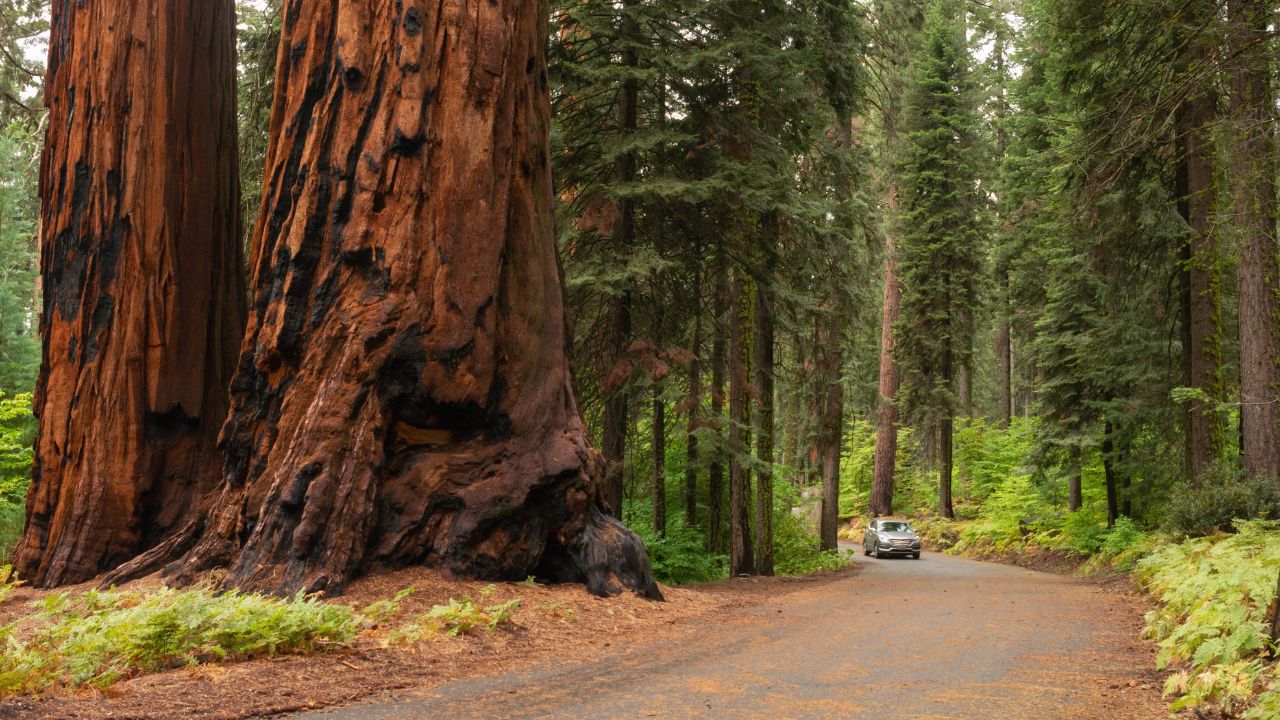
The drive south toward Sequoia and Kings Canyon adds a different kind of scale. The General Sherman Tree in Sequoia’s Giant Forest is the largest tree in the world by volume, and the short paved trail to it gives even time-limited visitors a direct encounter with the giant sequoias.
Mountain roads make this route slower than the mileage suggests. In Sequoia and Kings Canyon, seasonal snow, construction, shuttle operations, and road closures can affect access to certain areas. The parks’ road conditions page is worth checking before the drive, especially in spring, fall, or winter.
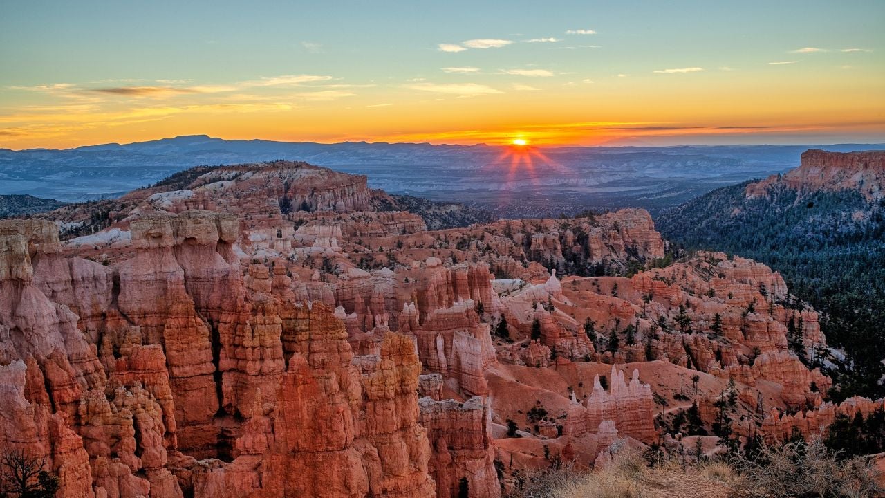
4. Desert to Hoodoos: Zion and Bryce Canyon Scenic Drive
Southwestern Utah turns a relatively short drive into a dramatic change of scenery. Zion National Park begins with sandstone walls, narrow valleys, and the Virgin River cutting through the canyon floor.
The main canyon requires a little planning during much of the year. Zion’s shuttle system serves the Zion Canyon Scenic Drive when private vehicles are restricted, giving visitors access to major trailheads and canyon stops without driving their own cars into the busiest stretch.
Easygoing stops still fit the route well. Riverside Walk gives travelers a relaxed introduction to the canyon without demanding a difficult hike, while longer trails can be added for visitors with more time, experience, and the right conditions.
A drive northeast brings a completely different mood at Bryce Canyon National Park. Hoodoos crowd the amphitheaters in strange, delicate formations, and the high elevation gives the park cooler air than Zion, especially in the morning and evening.
Bryce is also one of the strongest night-sky stops on this list. The National Park Service notes that the park’s high elevation, clean air, and remote location help create some of the darkest skies in the country. Sunrise, sunset, and a clear night can each make the same landscape feel like a different place.
5. Colorado Plateau to Desert Valleys: Mesa Verde and Monument Valley

Southwestern Colorado and the Four Corners region give this route a different kind of depth. Mesa Verde National Park protects cliff dwellings and archaeological sites connected to the Ancestral Pueblo people, with mesa-top roads leading to wide views and important cultural stops.
The most memorable cliff-dwelling visits require planning. Mesa Verde’s cliff dwelling tours page says reservations are required to enter all cliff dwellings except Step House, and the 2026 tour season runs from May 4 through October 21. Drive times inside the park can also be longer than expected, with some sites 55 to 90 minutes from the entrance.
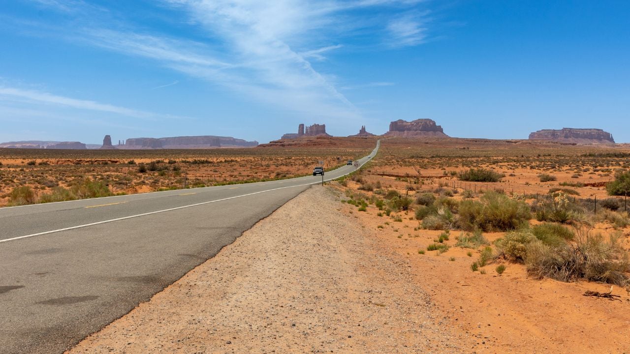
Continuing south and west brings travelers toward Monument Valley Navajo Tribal Park, one of the most recognizable desert landscapes in the American West. Sandstone buttes rise from the valley floor, creating the kind of view that has shaped decades of Western imagery.
Monument Valley is not managed like a U.S. national park. It lies within Navajo Nation, and Navajo Nation Parks & Recreation sets its own entrance fees, rules, and road guidance. The 17-mile loop road is natural dirt and can be rough, with deep sand in places, so visitors should check current conditions and vehicle guidance before driving it.
Sunset gives this route a memorable finish. Long shadows sharpen the buttes, the valley floor darkens, and the scale of the landscape becomes easier to feel from the road. After Mesa Verde’s cliff dwellings and the open desert drive into Navajo Nation, the trip ends with a sense of distance that feels earned.