
August has a way of making every road feel like it was paved specifically for your enjoyment. The days are long enough that you won’t run out of daylight before you run out of gas, and the weather is finally cooperating instead of plotting against your weekend plans. There’s something about late summer that makes even your daily commuter feel ready for adventure; though let’s be honest, it’s probably just happy to stretch its legs beyond the grocery store parking lot.
This is the season when driving transforms from transportation into therapy. The sun hangs around long enough for proper golden hour photography (your Instagram followers will thank you), and the roads are filled with fellow enthusiasts who’ve finally escaped their air-conditioned offices.
Whether you’re chasing mountain curves that’ll make your suspension earn its keep or coastal stretches where the only thing faster than your car is how quickly you’ll burn through your camera’s memory, August delivers the goods.
Roads That Carry the Spirit of Late Summer

The perfect August drive combines three elements: scenery that doesn’t require a filter, roads that remind you why you love driving, and timing that lets you enjoy both without melting. These routes were chosen because they offer something special during late summer — whether it’s high-altitude relief from the heat, coastal breezes that make convertible weather, or simply roads that look their absolute best when the light hits just right.
Some of these drives will test your car’s cooling system. Others will test your willpower to stay under the speed limit. All of them will remind you why you chose four wheels over public transportation, and why August is the month when roads stop being mere pavement and start being invitations.
These 12 roads will take you across the United States, all offering something special and memorable. We stuck to this dozen to give you an incredible variety as you plan your next road trip.
Blue Ridge Parkway: North Carolina and Virginia
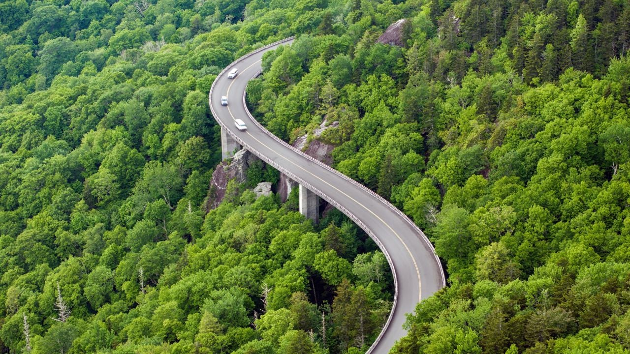
Length: 469 miles of curves that’ll make your sports car weep with joy
Elevation Range: 649 feet to 6,050 feet — your turbo will get a workout
Speed Limit: 45 mph maximum (which is actually perfect for this road)
The Blue Ridge Parkway is what happens when engineers decide to build a road that follows every beautiful ridge instead of taking the sensible route. The highest point reaches 6,053 feet at Richland Balsam, which means your naturally aspirated engine might start wheezing a bit, but the views will take whatever breath you have left.
In August, this road becomes a 469-mile escape from summer heat without requiring a trip to your mechanic afterward. The elevation changes create natural air conditioning; your car will thank you, and so will your passengers when they’re not cranking the A/C. The curves here aren’t the aggressive hairpins that’ll make your tires squeal in protest; they’re the kind of sweeping bends that let you settle into a rhythm and actually enjoy the drive instead of white-knuckling the steering wheel.
This road attracts RVs like honey attracts bears. But here’s the thing: the parkway was designed for leisurely driving, so even getting stuck behind a 40-foot motorhome isn’t the end of the world. Consider it forced meditation, or an opportunity to appreciate the scenery instead of obsessing over your lap times.
Pacific Coast Highway: California

Length: 656 miles along California’s coastline (plus another 1,000 miles if you’re feeling ambitious)
Construction: Started in 1919, completed in 1930 — construction ongoing right now
Real Talk: About 150 coastal miles will take you four hours if you actually follow the coast
The PCH is what happens when someone decides to build a road that prioritizes views over practicality, and frankly, we’re all better for it. The 518-mile section between San Francisco and southern Los Angeles is where your car becomes a front-row seat to the Pacific’s greatest hits reel.
August is prime time here because the marine layer finally takes a vacation, giving you clear views instead of driving through fog that makes your headlights as useful as a chocolate teapot. The road hugs cliffs that would make your insurance adjuster nervous, but that’s half the charm. Every curve reveals another postcard moment, assuming you can resist the urge to floor it on the straightaways.
Always drive north to south so the coast’s on your right: not just for the views, but because making spontaneous stops is easier when you’re not crossing traffic. Your passenger will appreciate not having to crane their neck to see the ocean, and you’ll appreciate not having to execute questionable U-turns for photo ops.
The PCH will test your car’s cooling system and your patience with tourists, but it rewards both with some of the most spectacular coastal driving on the planet. Just don’t expect to maintain highway speeds; this road demands to be savored, not conquered.
Going-to-the-Sun Road: Montana

Length: 50 miles of engineering that laughs at physics
Elevation: Peaks at 6,646 feet at Logan Pass
Lane Width: Narrow enough to make you question your vehicle choice
Season: Fully open in August (finally!)
Going-to-the-Sun Road is what happens when engineers decide to carve a path through terrain that clearly didn’t want a road. This 50-mile stretch through Glacier National Park was completed in 1932, back when “safety regulations” were more like “safety suggestions” and builders had the audacity to think they could improve on millions of years of geological work.
In August, you finally get the full experience since snow doesn’t block the high passes, though you’ll still see patches of the white stuff reminding you that Mother Nature isn’t entirely convinced about this whole “summer” concept. The road clings to mountainsides with the confidence of someone who’s never heard of erosion, delivering views that make you understand why people buy dashcams.
This road has vehicle restrictions for a reason: anything over 8 feet wide or 21 feet long stays home. Your lifted pickup might feel emasculated, but your sports car will feel right at home on curves that demand respect rather than raw horsepower. The pace is necessarily slower here: not because of speed limits, but because stopping to process the scenery is involuntary.
Wildlife sightings are common, from mountain goats who’ve mastered cliff-hanging better than your favorite action hero to marmots that couldn’t care less about your schedule. The road tests your driving skills and rewards them with memories that’ll make every other mountain drive seem a little ordinary.
Overseas Highway: Florida Keys

Length: 113 miles of island-hopping magic
Bridges: 42 of them, including the famous Seven Mile Bridge
Elevation: Basically sea level (your turbo won’t even notice)
Unique Feature: You’re literally driving on water
The Overseas Highway is the result of someone looking at a chain of islands and saying, “You know what this needs? A road.” It’s 113 miles of bridges and causeways connecting dots of land that were never meant to be connected, and it’s absolutely brilliant. This road proves that sometimes the most audacious engineering projects create the most unforgettable drives.
In August, you get the full tropical experience without the snowbird crowds that turn winter driving into a patience-testing exercise. The water on both sides shifts from turquoise to deep blue, like someone’s constantly adjusting the saturation settings, and the bridges give you the sensation of flying low over the ocean in your car.
The Seven Mile Bridge is the star of the show: a concrete ribbon stretching across open water that makes you feel like you’re driving on the ocean itself. Your car’s engine will barely break a sweat on the flat terrain, but your camera’s memory card will get a serious workout. The views change every few miles as you hop from key to key, each one offering its own flavor of tropical paradise.
This road attracts every retiree with an RV and a death wish for speed limits. But the forced slower pace works in your favor: this isn’t a road for setting land speed records; it’s for letting the salt air work its magic while you contemplate how humans managed to build something this audacious across open ocean.
Trail Ridge Road: Colorado

Length: 48 miles of high-altitude heroics
Peak Elevation: 12,183 feet — where your engine learns humility
Season: Open May through October (weather permitting, aka “when nature allows”)
Fun Fact: Highest continuous paved road in North America
Trail Ridge Road is where your car discovers what “thin air” really means. At over 12,000 feet, this road through Rocky Mountain National Park exists in an altitude zone where both you and your engine will be working a little harder than usual. If you’ve ever wondered how your naturally aspirated engine performs at altitude, this road will provide a comprehensive education.
August is peak season here, and for good reason: the road is fully open, the wildflowers are putting on their annual show, and afternoon thunderstorms add just enough drama to keep things interesting. The views stretch so far you’ll start questioning the marketing claims of every other “scenic route” you’ve ever driven.
This road doesn’t mess around with gentle elevation changes. It climbs decisively into alpine territory where the trees give up and the landscape becomes a moonscape of granite and sky. Your car will appreciate the cooler temperatures after the climb, and you’ll appreciate having functioning brakes for the descent.
The wildlife here operates on mountain time, which means elk might decide to hold up traffic for an impromptu photo session. Your schedule becomes secondary to theirs — consider it part of the charm. The combination of extreme elevation, pristine wilderness, and roads that feel like they’re borrowing space from the sky makes this drive feel less like transportation and more like temporary flight.
Kancamagus Highway: New Hampshire

Length: 34.5 miles of White Mountain perfection
Elevation: 800 to 2,855 feet — gentle enough for your commuter car
Curves: Enough to keep you engaged, not enough to make you dizzy
Nickname: “The Kanc” (because apparently even highways need street cred)
The Kancamagus Highway proves that you don’t need death-defying elevation or cliff-hugging terror to create a memorable drive. This 34.5-mile stretch through New Hampshire’s White Mountains focuses on the fundamentals: smooth pavement, well-banked curves, and scenery that changes every few miles like nature’s own slideshow.
August here means deep green forests that provide natural air conditioning and rivers that actually stay cold enough to shock you awake if you decide to take a dip. The road follows the Swift River for much of its length, giving you a constant soundtrack of flowing water that’s infinitely more soothing than your usual road rage playlist.
This isn’t a road that’ll challenge your driving skills or your car’s performance envelope. Instead, it challenges your ability to drive past scenic overlooks without stopping. The curves are telegraphed well in advance, the grades are reasonable, and the pavement quality suggests that New Hampshire actually cares about its roads (unlike certain other states we could mention).
The Kanc attracts fewer crowds than its more famous cousins, which means you’re more likely to have stretches of road to yourself. It’s the kind of drive that reminds you why you fell in love with driving in the first place: no stress, no drama, just you, your car, and roads that were built by people who understood that getting there can be better than being there.
Natchez Trace Parkway: Mississippi to Tennessee

Length: 444 miles of historical cruising
Speed Limit: 50 mph (enforced like they mean it)
Commercial Traffic: Banned (hallelujah!)
Vibe: Like driving through a nature documentary
The Natchez Trace Parkway is what roads looked like before someone decided they needed to be straight, fast, and efficient. This 444-mile route follows an ancient path used by everyone from Native Americans to 19th-century traders, and it’s been preserved as a National Parkway, which means no billboards, no truck stops, and no semis trying to draft off your rear bumper.
August on the Trace means warm days under a canopy of green that creates natural shade tunnels. The road meanders like it’s got nowhere urgent to be, which is perfect because neither do you. Speed limits top out at 50 mph, and honestly, you won’t want to go faster. This is driving for people who remember when roads were about the journey, not just the destination.
The absence of commercial traffic is the Trace’s secret weapon. No 18-wheelers blocking your view, no delivery trucks running late – just passenger vehicles and the occasional motorcycle whose rider clearly has their priorities straight. The road surface is smooth enough to make you wonder why other highways can’t figure out basic pavement maintenance.
Wildlife viewing comes standard — deer, wild turkeys, and other creatures that have learned to coexist with the slow-moving traffic. Historic sites dot the route, offering glimpses into what travel looked like when horsepower meant actual horses. It’s driving meditation for people who think mindfulness retreats are overpriced.
Columbia River Gorge Scenic Highway: Oregon

Length: 75 miles of waterfall-adjacent driving
Waterfalls: More than you can count (seriously, stop trying)
Engineering Marvel: Historic Columbia River Highway, completed 1922
Bonus: Your car gets a free wash from waterfall mist
The Columbia River Gorge Scenic Highway is what happens when early 20th-century engineers decided that roads should be works of art, not just transportation. Completed in 1922, this route was designed to showcase natural beauty rather than simply get you from A to B as quickly as possible – a radical concept that modern highway planners seem to have forgotten.
August brings perfect conditions for appreciating both the engineering and the waterfalls. Multnomah Falls drops 620 feet in two tiers, creating enough mist to provide natural air conditioning for your car. The historic stonework and viaducts prove that infrastructure can be beautiful when someone actually cares about aesthetics.
The road winds through a landscape where every bend reveals another waterfall, creating a driving experience that’s part scenic tour, part geological education. Your windshield will need occasional cleaning from the mist, but consider it a small price for driving through what amounts to nature’s own car wash.
This route attracts cyclists, which means sharing the road with lycra-clad enthusiasts who’ve discovered that two wheels can be almost as much fun as four. The grades are reasonable, the curves are well-engineered, and the scenery makes you understand why Oregon has such a devoted following among driving enthusiasts.
Big Sur Coast: California

Length: 90 miles of clifftop drama
Elevation Changes: Sea level to 1,200 feet (your brakes will get a workout)
Curves: 150+ significant turns (bring your A-game)
Reality Check: Landslides happen; check road conditions first
Big Sur is driving for people who think the Pacific Coast Highway needs more drama and fewer guardrails. This 90-mile stretch of Highway 1 between Carmel and San Simeon clings to cliffs that drop straight into the Pacific, creating a driving experience that’s equal parts exhilarating and terrifying.
August offers the best weather window for tackling Big Sur’s challenges. The marine layer takes a break, giving you clear views instead of driving through fog thick enough to cut with a knife. The road demands your full attention; this isn’t a place for cruise control or casual lane changes. Every curve is a commitment, and the drop-offs provide natural motivation for smooth inputs and steady hands.
Your car will earn its keep here. The constant elevation changes mean your brakes and engine get a real workout, while the narrow lanes and lack of shoulders remind you that precision matters. This isn’t a forgiving road, but it’s an honest one: it rewards good driving and punishes overconfidence with equal measure.
Landslides are a fact of life here, turning road trips into geological roulette. Check CalTrans before you leave, because discovering a road closure 45 miles into your journey is the kind of plot twist that ruins even the best driving day. When it’s open, though, Big Sur delivers driving experiences that’ll spoil you for every other coastal road.
Beartooth Highway: Montana and Wyoming

Length: 68 miles of high-altitude bragging rights
Peak Elevation: 10,947 feet — where the air gets interesting
Season: Open late May through October (if you’re lucky)
Switchbacks: Enough to make your passenger feel car sick
The Beartooth Highway earns its reputation as one of America’s most beautiful drives by making you work for it. This 68-mile route between Red Lodge, Montana, and Cooke City climbs to nearly 11,000 feet through switchbacks that’ll test your transmission’s resolve and your passenger’s stomach contents.
August is when the Beartooth shows off properly. Snow finally retreats from the high passes (mostly), revealing alpine lakes that look like someone spilled liquid mercury across the landscape. The road climbs through ecosystems like a vertical nature documentary, starting in forested valleys and ending in terrain that looks suspiciously like Mars.
Your car will notice the altitude: power drops, engines work harder, and cooling systems get a real test. But the payoff is worth every labored RPM. Views stretch across three states from the high plateaus, and the sense of accomplishment from conquering this road will fuel your driving stories for years.
The switchbacks are the real stars here, engineered with just enough banking to keep you glued to the road while providing constant reminders that gravity still works. This isn’t a road for setting speed records; it’s for proving that sometimes the best driving happens when you slow down and let the mountain set the pace.
Skyline Drive: Virginia

Length: 105 miles of ridge-running perfection
Elevation: Averages 3,000 feet — sweet spot for summer driving
Overlooks: 75 official viewpoints (plan your stops accordingly)
Wildlife: Deer with no respect for your schedule
Skyline Drive through Shenandoah National Park is the Blue Ridge Parkway’s more refined cousin — same mountain charm, fewer tourists with questionable driving skills. The road runs along the ridge of the Blue Ridge Mountains for 105 miles, providing constant elevation that keeps things cool when the valleys below are baking.
August delivers perfect conditions: clear skies for the overlooks, comfortable temperatures for top-down driving, and wildlife that’s active enough to provide entertainment without creating insurance claims. The 75 official overlooks mean you’ll never be more than a few miles from a photo opportunity that’ll make your social media followers question their life choices.
The road itself is a masterclass in scenic highway design. Gentle curves that follow the natural ridge line, well-maintained pavement that won’t assault your suspension, and grades that challenge neither your engine nor your driving skills. This is driving for people who understand that sometimes the best performance comes from restraint rather than aggression.
Deer are a constant presence here, operating on their own schedule with complete disregard for yours. They’ve mastered the art of appearing exactly when you’re enjoying a spirited pace through a perfect curve. Consider them nature’s speed enforcement: more effective than any radar gun and considerably more photogenic.
Route 100: Vermont

Length: 216 miles of pastoral perfection
Terrain: Rolling hills that won’t stress your transmission
Attractions: Covered bridges, maple syrup, and people who wave
August Special: Fresh corn stands every few miles
Route 100 is Vermont’s secret weapon against the aggressive driving culture that’s infected most of America. This 216-mile route wanders through the heart of the Green Mountains like it’s got all day and no particular place to be, which, frankly, should be your attitude when driving it.
August transforms Route 100 into a rolling advertisement for why rural America still matters. Fresh corn stands appear every few miles, manned by people who still believe in making change from a coffee can and trusting strangers. The road winds past farms where the hay is actually cut by people who know what they’re doing, creating scenes that would make a John Deere commercial jealous.
Your car will appreciate the moderate elevation changes and well-maintained pavement that suggests Vermont actually spends its tax money on infrastructure instead of bureaucratic studies about infrastructure. The curves are gentle enough for spirited driving without being aggressive enough to upset your passenger or local wildlife.
Covered bridges provide natural photo opportunities and remind you that road infrastructure used to be built by craftspeople who took pride in their work. The bridges are still functional, still beautiful, and still capable of making you slow down and appreciate details that modern construction tends to overlook.
Late Summer Escapes You’ll Never Forget

August driving isn’t just about escaping the heat: it’s about rediscovering why you chose a car over public transportation in the first place. These roads remind you that driving can be art, therapy, and adventure all wrapped up in a tank of premium gasoline and a day with nowhere urgent to be. Fair warning, however: You will probably need AC, though.
The best August drives combine three elements: roads that respect your car’s capabilities, scenery that justifies the fuel consumption, and weather that makes you grateful for retractable roofs and removable tops. Whether you choose high-altitude relief from summer heat or coastal breezes that make every mile feel like vacation, August delivers driving conditions that’ll spoil you for every other season.
So which road calls to you first? The mountain passes that’ll make your engine work for its views? The coastal routes where salt air mingles with premium gasoline fumes? Or the pastoral backroads where the biggest decision is which farm stand has the best corn? Whatever you choose, August is waiting to remind you that sometimes the best destination is the road itself.