Some trips fall apart when the schedule gets too ambitious. A trail becomes a photo stop, lunch turns into a rushed sandwich, and the best stretch of coast passes by from a car window.
Kiso Valley, Portugal’s Vicentina Coast, Jeju Island, Dordogne-Périgord, the Outer Hebrides, and Prince Edward Island ask for a slower pace. Their best hours sit on footpaths, village streets, riverbanks, beaches, markets, and coastal roads where stopping matters more than distance.
Wooden post towns in Japan, Atlantic cliff paths in Portugal, lava-stone walls on Jeju, Dordogne market stalls, Hebridean beaches, and PEI’s red cliffs all need space between major stops. Rush them, and the trip becomes scenery glimpsed through glass.
Walking distances, ferry times, trail conditions, weather, meal hours, park rules, and daylight shape the day in these places. The strongest version of each trip usually has fewer stops, better timing, and enough room for one slow meal, one long view, and one stretch of road or trail that was not overplanned.
1. Kiso Valley, Japan
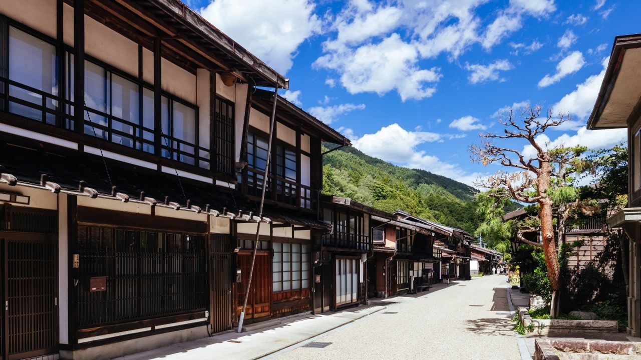
Kiso Valley is built for walking. The old Nakasendo route passes through forest, post towns, wooden houses, small bridges, fields, water channels, and mountain air instead of pushing visitors from one crowded landmark to the next.
Japan’s official tourism site describes Kiso as a rugged, forested valley in southwestern Nagano, known for historic towns, sacred Mount Ontake, and the best-preserved section of the old Nakasendo merchant trail. The valley feels quieter than Japan’s larger sightseeing routes because the main experience happens between villages, not only inside them.
The Magome-to-Tsumago walk is the classic section. Visit Kiso says the trail is roughly 8 kilometers long, easy to moderate, well signposted in English, and takes about three hours at a leisurely pace. The route crosses countryside, forest, local roads, and preserved village streets, so the timing should leave room for snacks, photos, and a proper look at the old buildings.
Travelers who hurry through Kiso miss the texture that separates the valley from a normal day trip: dark wood, old signs, stone paths, roadside water, forest shade, and houses facing the street as if they still expect walkers from another century. A night in or near one of the post towns gives the area a quieter evening and morning than a rushed visit from a larger city.
2. Alentejo and Vicentina Coast, Portugal
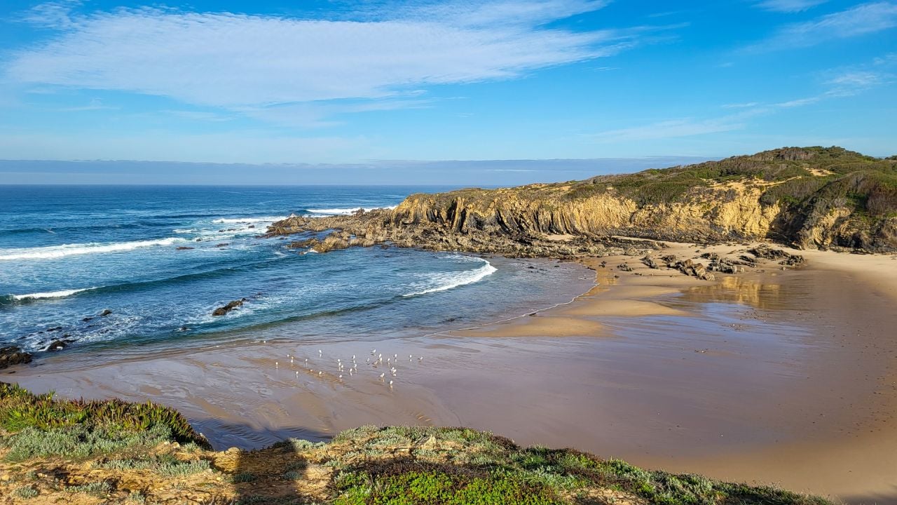
Portugal’s southwest coast is better at walking speed. Cliffs drop toward Atlantic surf, sand paths cut through low vegetation, fishing villages sit behind beaches, and wind keeps the coastline from feeling polished or overmanaged.
Rota Vicentina says its walking network covers 750 kilometers across the southwest of Portugal, including the Historical Way, the Fishermen’s Trail, and Circular Routes. That scale makes the region a place for chosen sections rather than a coast to “finish.”
The Fishermen’s Trail is the section many travelers picture first: narrow cliff paths, wide beaches, sea stacks, whitewashed villages, and long views back along the shore. One short stage with seafood and a beach pause usually leaves a stronger memory than a rushed route through too many viewpoints.
The coast needs respect as well as admiration. Wind, sun, loose sand, exposed cliffs, and limited shade all affect the walk. Start early, carry water, check trail distances, and leave the afternoon for a village meal or a quiet beach instead of another long push.
3. Jeju Island, South Korea
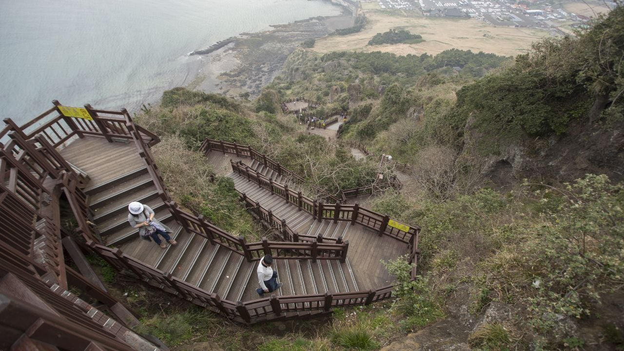
Jeju becomes more interesting when travelers leave the car and follow the island edge on foot. Lava-stone walls, small villages, wind, ocean views, black rock, fields, beaches, and fishing harbors give the coastline its slower detail.
The Jeju Olle Trail official route guide lists 437 kilometers across 27 routes around the island, with section distances, walking times, and difficulty levels. That structure lets visitors choose one manageable stretch instead of treating the island like a checklist of volcanic landmarks.
A slower visit might center on one Olle route, a village lunch, a beach stop, and an evening near the water. The point is not to see the entire island at once. The better memory comes from the walls, paths, gates, sea air, and small settlements between the famous stops.
Jeju’s weather and distances deserve attention. Wind, rain, heat, bus schedules, and route difficulty change the plan quickly. Pick one section, check the walking time, and leave enough energy for a meal or coffee after the trail instead of squeezing in another distant sight.
4. Dordogne-Périgord, France
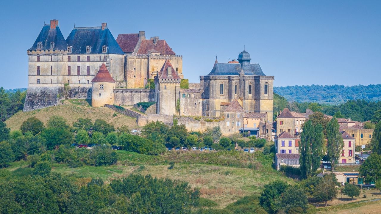
Dordogne-Périgord is a region of rivers, limestone cliffs, villages, castles, caves, walnut trees, markets, and long lunches. It loses something when every château and village becomes another pin on a map.
France’s official tourism site describes Périgord-Dordogne through vast river valleys, rock formations, caves, castles, and some of France’s most beautiful villages. Visit Dordogne Valley also points visitors toward castles, caves, Rocamadour, Sarlat, Bergerac, bastide towns, and villages known for their beauty.
The region feels richest when food, water, and old stone share the same day. A morning market in Sarlat or another town, a riverside lunch, a slow village walk, and one château or cave visit leave a stronger memory than hours spent driving from site to site.
Meal timing matters here. Markets are best early, lunch can stretch longer than expected, and village streets look different in late light after tour groups thin out. Leave time for walnuts, duck, truffles, cheese, wine, and the riverbanks between the famous stops.
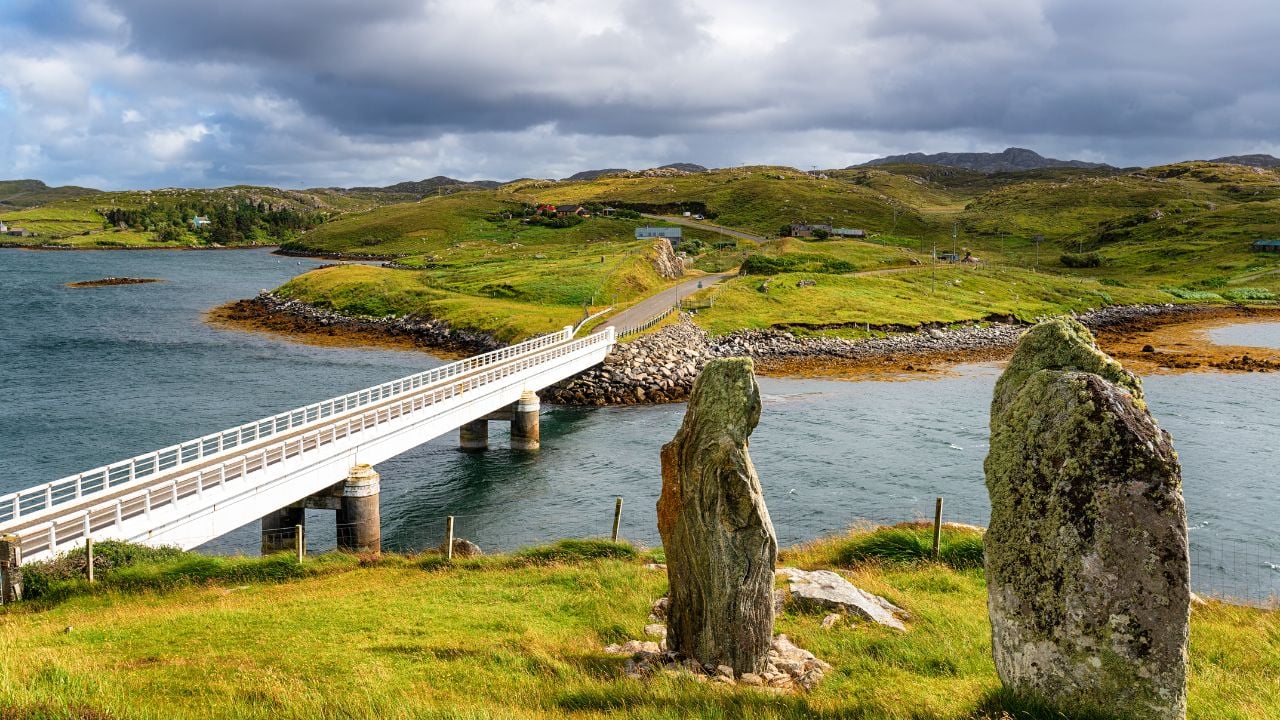
5. Outer Hebrides, Scotland
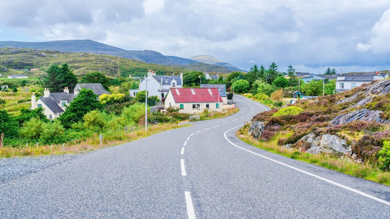
The Outer Hebrides change the pace with ferries, single roads, wide skies, empty beaches, machair, moorland, and weather rolling in from the Atlantic. The islands reward travelers who leave room for delays, long light, and roads that seem to end at sand or sea.
Visit Outer Hebrides describes the archipelago as an interconnected chain of Atlantic islands off Scotland’s northwest coast. VisitScotland highlights islands such as Lewis and Harris, Barra, and North Uist, with beaches, hills, machair, moor, wildlife, and travel ideas across the chain.
A slow day here might follow a beach road, pause at a viewpoint, continue toward a ferry, then end with seafood or a small island café. The landscape has a quiet scale: white sand, turquoise water, stone houses, peat-dark hills, and grasses moving in the wind.
Transport controls the trip more than ambition. Visit Outer Hebrides lists ferry routes between islands and mainland ports, and those crossings need to be built into the itinerary from the start. Weather, Sunday openings, accommodation distances, and ferry timing all matter.
6. Prince Edward Island, Canada

Prince Edward Island slows the trip with red cliffs, low farm roads, lighthouses, beaches, seafood, small communities, and long views over the Gulf of St. Lawrence. The island feels gentle, but the details are strong: red soil, white churches, lobster rolls, dunes, and wind moving across open fields.
Tourism PEI encourages visitors to “lose the itinerary,” pointing to wandering trails, endless beaches, and unique experiences across the island. That advice fits a place where a beach walk, a small harbor, a farm stand, and dinner near the water can carry a day without much noise.
Parks Canada describes Prince Edward Island National Park through sandy beaches, red cliffs, wind-sculpted dunes, cycling paths, picnic spots, lighthouses, woodlands, ponds, birds, and coastal bays. Those are not background details. They are the main reason to leave time for walking, cycling, picnicking, and stopping near the shore.
A slower PEI day starts on a beach, continues along a cycling path or country road, pauses for seafood, then ends near a lighthouse or harbor. Weather, park access, beach conditions, and driving distances still shape the plan, but the island is strongest when the schedule leaves room for water, food, and a second stop that was not on the list.