When I moved to Colorado, I knew I had to find good hikes without driving all over the state. That led me to explore the day hikes near Denver. I’m still on that quest, but after almost a year here, I’ve been able to do some pretty nice trails across the Front Range.
As I compiled my list, I prioritized those without a long drive and those that most people should be able to do. These are by no means the best of the best – mostly because I don’t think there are too many 10/10 hikes near the city.
Still, you’re in for enjoyment, time in nature, and solid views as you hit these trails. In the end, that’s all that really counts, right?
Aiming for under 45 minutes from downtown Denver
What does “near Denver ” mean? That’s entirely subjective and varies. I live on the east side of Denver, so it takes me 45 minutes without traffic to reach Boulder, but Breckenridge is only 90 minutes away because it’s entirely on the highway.
So, for this best day hikes near Denver article, I’m going to start the proverbial clock from downtown Denver and go from there. I’m aiming to keep this between 45 minutes and 75 minutes from Denver. Some of these may be a shorter or longer drive depending on your home.
I didn’t include any trails in Rocky Mountain National Park or anything on the western side of the Eisenhower/Johnson Tunnel.
Here Are My Favorite Hikes Near Denver (Up to ~75 minutes)
These are just the ones I’ve done so far in my less than one year living in Denver. I’ll be adding to this post and my best hikes in Colorado article as I explore more this summer.
Elevation gains are from my Garmin Fenix watch and may differ from what you see on AllTrails.
Last thing to note, these are fine trails. Nothing great, but that’s what you get when you live in Denver, and it’s all flat to one side, and the better hikes are much further into the mountains than “near Denver.”
1. Royal Arch Trail – Boulder
If you’re looking to avoid some of the crowds in the Flatirons area, this is a great option. It won’t be empty by any means, but it’s a bit harder than the popular routes, so you may get a little reprieve and some peace and quiet in nature.
The trail does some rollercoastering, with calf-burning steps to and from the arch on the back half. Once at the arch, you’ll have lovely views of downtown to the southeast.
Dogs are allowed on this hike.
Unfortunately, I took zero photos on this trail – go figure. But it’s worth it.
-
- Length: 3.4 mi (out & back)
-
- Elevation Gain: ~1,400 ft
-
- Difficulty: Hard
2. Mount Galbraith Loop – Golden

I love this trail for three reasons. First, it’s a fantastic training hike. From my place, it’s a 28-minute drive mid-day, mid-week, and the parking lot isn’t too full. Secondly, it offers nice views of ridgelines and snowy peaks once you reach the top portion.
Lastly, this trail is hiker-friendly almost year-round. Save some snowy days when the trail is too icy; you can do the entire loop in less than two hours if you’re moving steadily.

-
- Length: 4.2 mi (loop)
-
- Elevation Gain: 925 ft
-
- Difficulty: Moderate
3. Rattlesnake Gulch Trail – Eldorado Canyon State Park

Rattlesnake Gulch Trail is one of the few on this list I’ve done twice.
Eldorado Canyon State Park is a really cool place, with impressive, colorful rock walls and a nice creek running through it. The trail isn’t long, but it has a steep section that out-of-towners will feel quickly.
I took my parents on this; they flew out from Phoenix for Christmas, and they definitely felt the altitude at almost 7,500 feet.
Note: Visitors during the summer months need a timed-entry reservation to visit on Saturdays, Sundays, and summer holidays (Memorial Day, Juneteenth, Independence Day, Labor Day) from May 1 through October 1 annually. Additionally, this is a state park, so entrance fees are present.
-
- Length: 3.8 mi (loop)
-
- Elevation Gain: ~985 ft
-
- Difficulty: Moderate
4. Bear Creek Trail to Panorama Point – Lair o’ the Bear Park (Morrison)

I was SHOCKED at how crowded this area was on a Sunday afternoon in April. As a still new-to-Coloradoan, this was one of the most crowded trails and parking lots I’ve ever been to. Usually, I’m out in the alpine, where fewer people visit.
But on this occasion, we wanted a quick hike to stretch our legs. I guess so did everyone else.
The trail is broken into two types. First, a flat walk along the creek for the first and last. Then, the middle part is your elevation change. But because this is a mountain-biking trail as well, the hike is mild, and we never felt too out of breath going up.

At the top, the views from Panorama Point were a lovely place to each lunch and soak up the view of the Colorado Rockies.
-
- Length: 6.4 mi (loop)
-
- Elevation Gain: 1,102 ft
-
- Difficulty: Moderate
5. Genesee Mountain Trail Outer Loop – I-70
This one is a fine hike. Nothing too special, but a nice walk in the forest and out of the flatness that we call home in Denver. One cool aspect of this hike is that you may get to see the Bison herd that calls this area home.
This loop trail has a few starting points, but we started at Patrick House Trailhead. If you do the loop clockwise, you’ll unfortunately have to hike along I-70 for half a mile.
-
- Length: 3.6 mi (loop)
-
- Elevation Gain: 456 ft
-
- Difficulty: Moderate
6. First and Second Flatiron – Boulder
One of the best hikes near Denver. The Flatirons are a gem, and this is one of many hiking options you can take in the area. There are a dozen or more varieties of trails you can take from Chautauqua Park to make your trip to the area worthwhile.
-
- Length: 3.1 mi (loop)
-
- Elevation Gain: ~1,350 ft
-
- Difficulty: Hard
7. Boulder Canyon Trail – Boulder

Another nice hike near downtown Boulder. Theoretically, you can start this in town and run/bike/walk up it. My wife’s family and I parked here and walked upstream along the creek until the trail crossed under the road for the second time. (I estimate we did about 2.5 miles in all.)
This is a great family-friendly trail, but keep in mind bikers frequent it, so keep younger kids close.
-
- Length: 2.4 mi (one way, out & back from mouth of canyon)
-
- Elevation Gain: 335 ft
-
- Difficulty: Easy (paved/gravel path, follows Boulder Creek)
8. Mesa Top & Cottonwood Canyon Loop – North Table Mountain Park

I did this one recently, and again, it’s a nice training hike to get in shape for when the mountains open up. Don’t really expect much else. It’s pretty brown and dull with lackluster views. It’s probably more of a mountain biking trail than anything. But for less than 30 minutes from home, it’s a nice way to get elevation in this flat city of ours.
But because of that, you can cruise up it. I did the entire trail at over 3 miles per hour while walking.
-
- Length: 4.5 mi (loop)
-
- Elevation Gain: 900 ft
-
- Difficulty: Moderate
9. Dinosaur Ridge Trail – Morrison

I had to throw this one in here because DINOSAURS! This is out by Morrison and a nice short walk to see fossils. The trail goes up and then down, so you have an uphill on both sides. It’s a unique place and the highest concentrations of dinosaur bones around Denver.
This is wonderful for families and those just looking to get outside for 75 minutes.
-
- Length: 2.2 mi (out & back, paved road)
-
- Elevation Gain: 252 ft
-
- Difficulty: Easy
10. Red Rocks and Morrison Slide Loop – Red Rocks Park/Matthews and Winters Park
Somewhat near Red Rocks but not exactly Red Rocks. This trail is easier to access from I-70 and offers a nice walk. It was snowy when I went, so that added to the be beauty with the contrast of red and white.
I’m sure there are more people on a weekend, but for my mid-week hike, there wasn’t a soul around!
-
- Length: 3.2 mi (loop)
-
- Elevation Gain: 692 ft
-
- Difficulty: Moderate
11. Lake Isabelle – Brainard Lakes Recreation Area

Easily the most stunning hike on this list. I was a little lax about allowing this on, but since it is so easy to reach from Denver, I had to include it. Lake Isabelle sits inside the Indian Peaks Wilderness, and during summer wildflower bloom, it is incredible!
It’s easily one of the best hikes near Denver and is relatively easy as well. Do note that you need a timed-entry permit to hike within the Brainard Lakes Recreation Area.
-
- Length: 4.5–6.6 mi (out & back, depending on parking lot)
-
- Elevation Gain: 675–750 ft
-
- Difficulty: Easy to Moderate
12. Silver Dollar Lake and Lake Murray – Guanella Pass
I loved this trail. It’s simple, yet pretty. This is one of the highest trailheads in the area, around 11,000 feet. The parking lot is small, so either get there early in the morning or in the afternoon when morning hikers are heading back.
It’s almost entirely above the treeline, so pack plenty of sunblock. The first lake is the prettiest, while the upper lake will give you some nice wind chill.
-
- Length: 4.2 mi (out & back)
-
- Elevation Gain: ~1,085 ft
-
- Difficulty: Moderate
13. Idaho Springs Reservoir and Chicago Lakes – Mount Blue Sky Road

I’ve only gotten to the Idaho Springs Reservoir, but if you keep going another three miles, you’ll reach Chicago Lakes. This trail is only an hour from Denver, making it possibly the best hike near Denver on this list.
You start off at 10,600 feet, then drop down to the water. If you want, you’ll then start the Chicago Lakes portion of the trail, which leads to an impressive backdrop of solid rock beneath Mount Blue Sky.
-
- Length: 3.6 mi to reservoir / 9.1 mi to Chicago Lakes (out & back)
-
- Elevation Gain: 751 ft to reservoir / ~2,142 ft to Chicago Lakes
-
- Difficulty: Moderate (to reservoir) / Hard (to Chicago Lakes)
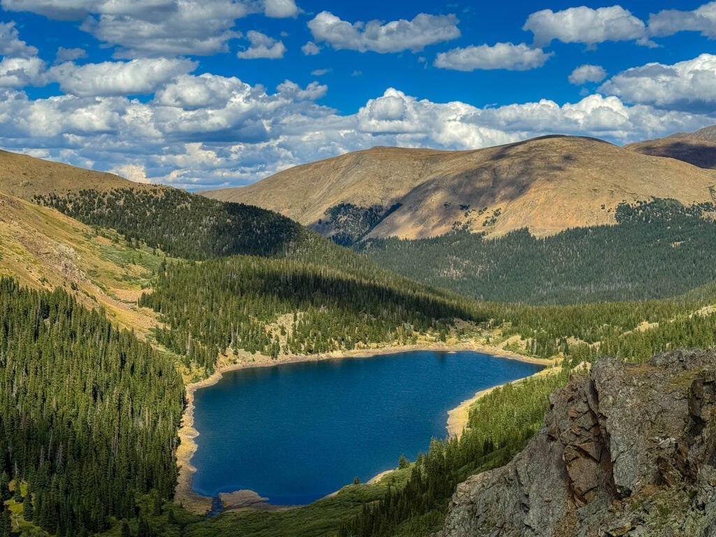
14. Crater Lakes – James Peak Wilderness

Crater Lakes is a lovely trail during the summer months with tons of wildflowers. It’s up at Moffett Tunnel at the end of a long, dirt road. This gets insanely crowded in the summer, and we likely added an extra mile onto our hiking total thanks to parking down the road.
The trail is relatively steady for most of it, before a set of switchbacks around the two-mile mark. This was one of the first hikes we did after moving to Denver, so we were pretty out of breath hiking around 10,000 feet.
This is a little outside the 75-minute window I mentioned at the top. That’s okay. Break some rules; see pretty things!
-
- Distance: 6 miles
-
- Elevation Gain: 1,500 feet
-
- Difficulty: Moderate