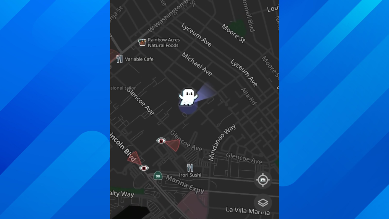
MapQuest is giving drivers a new way to see surveillance cameras positioned along American roads, including those operated by Flock Safety.
The longtime navigation service announced a feature on October 15 that marks known camera locations directly on its mobile maps. Drivers can now identify equipment that may be recording their vehicles as they travel.
The update arrives as Flock Safety’s camera network faces growing scrutiny over privacy, data access, and the use of information collected from passing vehicles by police departments.
For MapQuest, a company once best known for directions people printed before leaving home, the new feature offers something its larger navigation competitors generally haven’t provided: a map of roadside surveillance equipment.
Surveillance Goes Visible
Embedded media follows; please allow a moment to load.
The Roads Have Eyes! 👁️
Turn on the Surveillance Layer in Map Options to see known license plate readers from Flock Safety, Motorola Solutions (Vigilant), Genetec, Axis Communications, Axon, Leonardo (ELSAG), Neology, Rekor, PlateSmart, Ubicquia, Verkada, and other outdoor surveillance cameras.[image or embed]
— MapQuest (@mapquest.com) October 15, 2026 at 3:49 PM
MapQuest introduced the feature with a simple message: “The Roads Have Eyes!”
To activate it, drivers open the MapQuest mobile app, access Map Options, and enable the Surveillance Layer.
Once activated, the map displays eyeball icons identifying known surveillance camera locations. Zooming closer reveals individual devices, and some locations include directional indicators showing where cameras are pointed.
Tapping a camera marker can provide additional details, including its coordinates, camera type, and viewing direction when available.
The feature is currently available through the mobile app rather than MapQuest’s regular website.
More Than Flock
Although Flock Safety is among the most recognizable names in automated license plate recognition, MapQuest’s announcement identifies equipment from numerous manufacturers.
Those include Motorola Solutions, Genetec, Axis Communications, Axon, Leonardo, Neology, Rekor, PlateSmart, Ubicquia, and Verkada.
Automated license plate readers capture images of passing vehicles and use software to identify license plate numbers. Depending on the system, the resulting records can include timestamps, locations, and vehicle identifiers.
Police departments use this information to investigate crimes, locate stolen vehicles, and search for vehicles connected to missing-person cases.
Privacy advocates, however, have raised concerns about the accumulation of vehicle movement records and the possibility of searches being conducted without sufficient oversight.
The controversy has prompted some communities to reconsider their camera programs, even as other jurisdictions continue expanding them.
Drivers Requested It
The new feature wasn’t simply an internal experiment.
MapQuest General Manager Doug Berger told Business Insider that displaying surveillance camera locations ranked among the three most requested features from users.
The company has not publicly clarified exactly where it obtains all of the camera location information.
Gizmodo reported that the information resembles data gathered through DeFlock, a community mapping project that documents license plate readers and other surveillance equipment.
That resemblance does not establish whether MapQuest directly uses DeFlock’s database.
There is another important limitation: the layer identifies known cameras, not necessarily every device operating along a particular route. Missing or outdated records could leave some equipment unmarked.
Nevertheless, the update makes information that previously required visiting specialized surveillance mapping websites accessible through an ordinary navigation app.
A New Direction
MapQuest launched in 1996 and became one of the earliest widely used online navigation services, long before smartphone navigation became commonplace.
Its new surveillance feature comes amid renewed attention to the platform.
Unlike traditional traffic alerts or speed camera warnings, the Surveillance Layer focuses on equipment that can collect information about vehicles traveling on public roads, even when their drivers aren’t suspected of wrongdoing.
For drivers curious about how much surveillance equipment is installed in their neighborhoods, the new layer lets them examine reported locations, camera types, and viewing directions without leaving their navigation app.